|
|
Durham Cemeteries
|
South Tyneside Cemeteries:
The Cemetery Department uses spreadsheets to maintain the grave space records for each of the
sections in their six cemeteries. The grave number and, where it exists, headstone name, is
recorded in the appropriate cell. Cells are coloured red to indicate a fallen headstone, and blue
where one is now upright. These latter headstones are checked yearly to verify that they are safe.
In essence, each spreadsheet is a section grave space map.
For each cemetery there is a map which allows for selection of individual sections. When displayed,
there are controls to zoom in and out, scroll up and down, and pann left or right. There is also an
option to print.
Maps available now are Boldon,
Harton,
Hebburn,
Jarrow,
Westoe and
Whitburn.
'CSV' data was obtained from the spreadsheets, and used to create Autocad DXF Input to a Cad Viewer.
An image file was then used to produce the individual maps.
Durham County has 46 open cemeteries and 98 closed churchyards. Should the 'Friends' of any of these
wish to produce similar maps, I would be interested to hear from them.
|
|
Hartlepool, Hart Warren, Spion Kop or Old Cemetery:
Opened in 1856, overlooking the sea, it must have appeared to be an ideal spot for
a cemetery. However, by about 1895 it was getting rather full, and with a Jews Cemetery on one side
and industrial sites on the other, the only possibility was to add an
Extension to the seaward side.
The sketch of the proposed extension, which was completed, appears to be the only document that has been made available
for public use. Sadly, it contains errors, the grave numbers in the area indicated to be 'Sheet 3', are incorrect.
The grave numbers should be in the range 134 to 231, not 133 to 211.
The sketch refers to sheets 1 to 4, which would probably have been Grave Space Maps. No trace of them had been found
in recent years up to 2010, it was assumed they had been detroyed. But miraculously, one surfaced, having been
discovered in the basement of Hartlepool Library. This Grave Space Map
covers what one supposes were sheets 3 and 4. No trace has been found of a similar map, which would have covered
sheets 1 and 2, or the one which would have been produced for the extension to the cemetery.
The map has been cleaned, showing the original colouring, together with the outlines of family plots marked in red.
Sadly, it has not been possible to correlate these plots with any of the large number of graves that have significant
memorial stonework. Hartlepool Council decided not to fund ongoing maintenance of the cemetery, justifying this by designating
it to be a wildlife conservation reserve. The cemetery is now completely overgrown, with large numbers of memorials sticking, somewhat
incongrouously, out of the undergrowth.
This graph shows the number of burials in the original part of the cemetery, together with those in the extension.
The sharp increase around about 1918 coincides with the flu epidemic in the UK.
The Burials Index for the cemetery, 1856 - 1997, can be viewd here.
|
|
Sunderland Cemeteries Grave Space Plans:
This section contains, to date, the grave space maps for six of the ten City of Sunderland cemeteries.
Those map sheets drawn up in the early years of each cemetery demonstrate a facinating attention to detail,
requiring real draughtsmanship skills. Sadly, this quality is rather lacking in later years, and it is probable that
ongoing updates have stopped in all cemeteries.
Sunderland, or Grangetown, Cemetery:
This Ward Layout shows the location of the wards within the cemetery.
A gallery showing the Grave Space Maps for each ward can be displayed by clicking on a ward in the above Ward Layout.
Castletown Cemetery:
This Cemetery Layout shows the layout of the wards in the cemetery.
Ward A and
Ward B
are the oldest, followed by
Ward C and
Ward D.
There is also a Lawned
section.
Clicking on any of these ward maps will produce an enlarged scale image.
Easington Lane Cemetery:
The four large wards shown in the
Ward Layout
form the
original part of the cemetery. There have been two
Extensions to the
cemetery, together with the addition of two lawned sections.
Again, clicking on either of these maps will produce a higher resolution image.
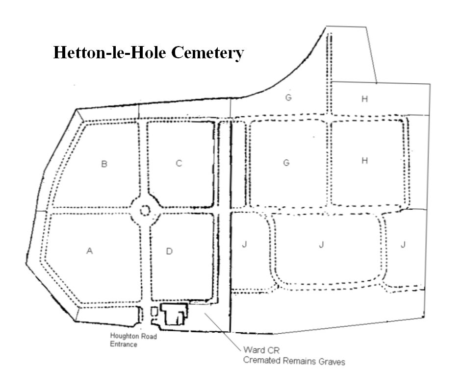
Hetton-le-Hole Cemetery:
The Ward Layout
shows the three major areas of the cemetery, each covered by a single grave space map. The earliest, dating from it's opening in 1891, is for
Wards A to D. and only shows the individual numbered grave spaces.
The second area, Ward J ,
shows the grave space numbers for the earlier burials, but adds the surnames for the later burials.
The last area, Wards G and H , shows
grave space numbers, surnames, and how many burials took place in each grave.
All three sheets are excellent examples of quality draughtmanship.
The images can be rotated to make it more convenient to read the grave space numbers and surnames.
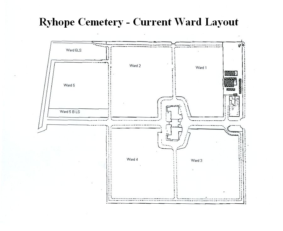
Ryhope Cemetery:
The Original Ward Layout
consisted of just four wards. Selecting any of the wards will show its four pages of grave space plans. Selecting the church or
chapel will show all sixteen pages.
The cemetery was extended by the addition of
Wards 5 and 6,
but this is not an accurate reflection of the current layout.
Ward 5 is fine, but Ward 5B LS
is simply a single row of grave spaces.
There is no grave space plan available for Ward 6 LS, but
Google Maps , showing the current layout
of the cemetery, suggests that it is not a Lawned Section.
Southwick Cemetery:
The cemetery is unusual in that it consists of a relatively large number of small sections.
Sections 1 to 3 date from the days before Southwick became part of Sunderland, and are somewhat
unusual.
Each grave space has the grave space number and the surname, but it also has the reference
number of the burial record.
The
Section Layout shows the positions of all the sections, but there are no grave space plans for Section FF.
|
|